Kanchenjunga Trekking

Kanchenjunga Trekking

Kanchenjunga trekking

"The Kanchenjunga Circuit Trek is the perfect place to go if you're searching for difficult terrain and unspoiled natural scenery"

In Nepal's far east, near the Indian state of Sikkim, is the well-preserved hidden gem known as Kanchenjunga. Few visitors are aware of the tough trekking route that encircles the Kanchenjunga Mountains, and most hikers avoid the route due to the need for special permits and difficult terrain. The Kanchenjunga Circuit Trek offers the opportunity to travel a quiet mountain trail perfect for those who like solitude, to the base camp of the third-tallest peak in the world. Before Mt. Everest was discovered, Kanchanjunga was regarded as the Highest peak of the world. Trekking the Kanchenjunga Circuit gives you the opportunity to see a diverse array of flora and fauna in addition to breathtaking views of the Himalayas.

Our Kanchenjunga Circuit Treks offers you an exciting opportunity to travel to both the base camps of Mt. Kanchenjunga i.e. North and South Base Camp via Sele La Pass. In comparison to other treks in Nepal, the Kanchenjunga Circuit Trek is extremely isolated and demands a high level of physical fitness. The strenuous trail is meant for thrill seekers looking for the most amazing experience of their lives. Admire stunning scenery of the Yalung Glaciers. You'll feel as though you're back in your long-forgotten home with the Kanchenjunga region's peace and heartwarming scenery. Kanchenjunga Circuit Trek will transport you back in time, unaffected by the passing of time. The stunning vistas of the Himalayas follow. Only the Kanchenjunga Circuit Trek offers some of the most fascinating views of the mountains, including the eight-thousanders, such as Mt. Everest (8,849 m/29,032 ft), Mt. Makalu (8,463 m/27,765 ft), and Mt. Lhotse (8,516 m/27,940 ft). Other mountains that are included in the trek's itinerary are Tent Peak (5,663 m/18,684 ft), Mt. Kambachen (7,902 m/25,925 ft), Mt. Janu (7,710 m/25,300 ft), etc.

Trip Details

  • Itinerary
  • Detail Itinerary
  • Trip Info
  • Weather
  • Equipment
  • Useful Info

Itinerary:

Day 01: Arrival in Nepal [1,330 m].
Day 02: Sightseeing around Kathmandu Valley - Trek Preparation [1,330 m]. "B,L,D".
Day 03: Fly from Kathmandu to Bhadrapur drive to Taplejung [1,462 m]. "B,L,D".
Day 04: Taplejung drive to Sekathum [1,576 m] - trek to Amjilosa [2,308 m]. "B,L,D".
Day 05: Amjilosa to Gyabla [2,730 m]. "B,L,D".
Day 06: Gyabla to Ghunsa [3,595 m]. "B,L,D".
Day 07: Acclimatization day at Ghunsa [3,595 m]. "B,L,D". 
Day 08: Ghunsa to Kambachen [4,050 m]. "B,L,D".
Day 09: Kambachen to Lhonak [4,790 m]. "B,L,D".
Day 10: Trek to Pangpema/Kanchenjunga North BC [5,388 m] - Lhonak [4,790 m]. "B,L,D".
Day 11: Lhonak to Ghunsa [3,595 m]. "B,L,D".
Day 12: Ghunsa to Sele Le [4,290 m]. "B,L,D". 
Day 13: Sele Le to Cheram [3,870 m]. "B,L,D".
Day 14: Cheram to Ramche [4,580 m] and return back to Cheram [3,870 m]. "B,L,D".
Day 15: Cheram to Tortong (2,995 m/9,824 ft.) 6-7 hours [2,995 m]. "B,L,D".
Day 16: Tortong to Yamphudin [2,080 m]. "B,L,D".
Day 17: Yamphudin to Thorpu [1,500 m]. "B,L,D".
Day 18: Thorpu to Birtamod [300 m]. "B,L,D".
Day 19: Drive from Birtamod to Bhadrapur then Fly to Kathmandu [1,330 m]. "B".
Day 20: Trip ends! Fly back home, taking with you the memory of a life time. "B".


Note: If the above itinerary does not meet your needs, we can design individualized travel plans based on your preferences.

Detail Itinerary:

Day 01: Arrival in Nepal [1,330 m]: A representative from Adventure Treks Nepal will be waiting outside the airport according to your flight time who will transfer you to the hotel. Briefing will be done once you have settled down. Please do let us know if you have any queries. Overnight in Hotel.

Day 02: Sightseeing around Kathmandu Valley - Trek Preparation [1,330 m] - (B):  After Breakfast we Proceed for sightseeing tour of Bhaktapur city 15 km from Kathmandu, known as city of Devotees and center of medieval art and architecture founded by King Anand Dev in 889 AD, visit Nyatpola temple, the most beautiful temple of Nepal, the 15th century palace of 55 windows, Golden gate and other place of Interest. Lunch Time: 1300hrs-14:00hrs PM: Visit Pashupatinath temple, one of the most sacred Hindu shrine in the World. The holy river Bagmati and the burning ghats and also visit one of the oldest and biggest stupa of Boudhanath. Overnight stay at Hotel.

Day 03: Fly from Kathmandu to Bhadrapur drive to Taplejung [1,462 m] - (B/L,D/): After breakfast at the Kathmandu hotel, you'll be driven to the airport to catch your flight to Bhadrapur. We travel to Taplejung by car from Bhadrapur, which should take us four to five hours. You will have the opportunity to see Nepal's unspoiled beauty while on the drive. (Flight 01 hour and drive 04-05 hours) Overnight stay at Tea House.

Day 04 Taplejung drive to Sekathum [1,576 m] - trek to Amjilosa [2,308 m] - (B/L,D/): We embarked on an adventurous trip towards Sekathum after breakfast in Taplejung. We will pass by other settlements along the way, including Taplethok, Tamewa, Hellok, and Lelep. Following the Tamor River, the road descends in the direction of Simbu Khola, which is where the Yalung Glacier meets the earth. Once we get to Sekathum, we start traveling along Ghunsa Khola. We travel across exposed terrain and a difficult ascent as we make our way towards Amjilosa. After taking in the breathtaking scenery and across multiple bridges over Ghunsa Khola, we arrive in the Tibetan settlement of Amjilosa. (Trekking 05-06 hours) Overnight stay at Tea House.

Day 05: Amjilosa to Gyabla [2,730 m] - (B/L,D/): After breakfast we continue on from Amjilosa to Gyabla, also called Kyapra. We keep traveling along our route through a thick woodland and a trail empty of human habitation. If we're lucky, we might be able to see red pandas today while hiking the Kanchenjunga Trail. We have access to breathtaking views of the mountains and multiple waterfalls after the uphill climb. We travel slowly and arrive at Gyabla village. (Trekking 05-06 hours) Overnight stay at Tea House.

Day 06: Gyabla to Ghunsa [3,595 m] - (B/L,D/): We will surpass the 3000 meter elevation level today. A steep slope into a gorge greets the day. Following the descent, we'll stroll through fir and rhododendron forests. This makes the trek easier. We hike along the riverbank to the stunning Yak pastures at 3210 meters in Pholey. The Tibetan town of Pholey boasts stunning potato fields. We're going to have a leisurely lunch break at Phole. We can see the effects of Tibetan Buddhist culture at Pholey. Pholey is home to a stunning monastery as well.The valley opens up beyond Pholey. Now, the trail winds through larch trees and verdant pastures. We shall descend to the Ghunsa Khola riverbed by following the trail.We shall enter Ghunsa village after going over the Ghunsa Khola bridge. (Trekking 05-06 hours) Overnight stay at Tea House.

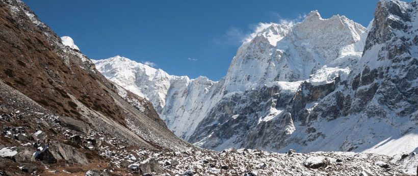
Day 07: Acclimatization day at Ghunsa [3,595 m] - (B/L,D/):  We are acclimating to altitude in Ghunsa village today. Our bodies need time to adjust to the shifting atmosphere when hiking at high altitudes. As we ascend to greater altitudes, the air becomes less oxygenated. Thus, we are prone to severe altitude sickness. Thus, following a particular altitude gain, we plan an acclimatization day. In the afternoon we will be hiking to surrounding areas to explore and to get our body used to with increased altitude. Overnight stay at Tea House.

Day 08: Ghunsa to Kambachen [4,050 m] - (B/L,D/): There is a risk of landslides along the route from Ghunsa to Kambachen. The route travels through Kanchenjunga North's untraveled paths. From Ghunsa, we will travel over the breathtaking terrain heading north. The track climbs gradually through a juniper and larch forest. We're going to stroll alongside the river's east bank. Along the way, there will be some stunning landscapes that we will come across. We'll walk the sand-and boulder-filled riverbank path. In 3720 meters, we will cross a river on a bridge made of wood and stone to arrive in Rambuk Kharka. The trail goes through a part with a waterfall and landslide just after Rampuk Kharka. Grateful for the beautiful views all around, we make our way down the mountainside. We shall reach Kambachen at last. Kambachen is a makeshift community including little stone teahouses. We have to give up some comfort when staying in tea houses. The amenities are simple. (Trekking 06-07 hours) Overnight stay at Tea House.

Day 09: Kambachen to Lhonak [4,790 m] - (B/L,D/): The trail now heads into a barren area. We'll walk over the landscape sculpted by the high-altitude glaciers' sharp blades. The path is devoid of settlements and dwellings. The path progressively ascends amongst the remnants of a moraine. The icy stones may cause your feet to slide. Move at a slow pace! The trail ascends the landslide slopes. At 4350 meters, we will arrive at the stunning Ramtang pasture region. The beginning of the Kanchenjunga glacier is at Ramtangat. It will be the stunning Ramtang Monastery that we encounter. Following a waterfall, the monastery is situated next to the bridge. The view is breathtaking.The trail keeps going along the river's north bank. We are going to traverse the Lhonak glacier. The point where the Lhonak and Kanchenjunga glaciers converge is quite amazing. Following the challenging portion, we will be surrounded by breathtaking mountains on all sides. The captivating 6344-meter-high Mera Peak sits to the east.Now we're going to get to the Riverside. We will eventually see the Lhonak village. (Trekking 06-07 hours) Overnight stay at Tea House.

Day 10: Trek to Pangpema/Kanchenjunga North BC [5,388 m] - Lhonak [4,790 m] - (B/L,D/): The north base camp of Kanchenjunga is known locally as Pang Pema. We are going to the North Base Camp of Mount Kanchenjunga today. This day is one of the highlights of the trek. We'll make our way up the trail gradually. We'll adhere to the moraine's line. The trail has some areas where landslides could occur. Take caution when you're walking. The hike would be easier if you use the trekking pole. The level, grassy plain basin of Kanchenjunga North Base Camp lies after all the rocky portions. Savor the sights of Kanchenjunga's majestic peak. After spending some time at the base camp we will return back to Lhonak for Overnight stay. (Trekking 08-09 hours) Overnight stay at Tea House.

Day 11: Lhonak to Ghunsa [3,595 m] - (B/L,D/): We are going to journey back to Ghunsa, retracing our earlier days.We will enjoy the breathtaking views of the Himalayas while traveling. Additionally, traveling the prior path from a new angle is a breathtaking experience.Savor the breathtaking surroundings as we make our way back. We will hike back, leaving the breathtaking vistas of Mount Jannu behind. Exercise caution when crossing glaciers and navigating landslides. (Trekking 06-07 hours) Overnight stay at Tea House.

Day 12: Ghunsa to Sele Le [4,290 m] - (B/L,D/):  We leave the trail to Gyabla and arrive in Sele Le. While we travel through the thick forest, there is a potential that we will spot snow leopards. There are small, remote villages with a few teahouses that are only open during the peak trekking season. There isn't another route linking the pathway to South Base Camp till Sekathum during periods of high snowfall. (Trekking 06-07 hours) Overnight stay at Tea House.

Day 13: Sele Le to Cheram [3,870 m] - (B/L,D/): This will be a difficult day for you! The Mirgin La Pass will be 400 meters above us. We will have a breathtaking view of Mt. Jannu along the ascent, along with Makalu, Baruntse, Chamlang, Kangchenjunga, and Kabru. Along the Sikkim border, the Himalayan range will also be visible. We'll hike to the 5,160-meter-high Mirgin La Pass and Lapsang La Pass. We will then link up with the Kanchenjunga South Treks by completing this. The high altitude passes are these ones. Here, the weather could present a number of challenges. Be courageous! Be ready for any challenges that may arise based on the weather. Enjoy the views of the surroundings. They will encourage you to continue trekking. We will hike around the ridges with a final descent to Tseram after a demanding day. (Trekking 06-07 hours) Overnight stay at Tea House.

Day 14: Cheram to Ramche [4,580 m] and return back to Cheram [3,870 m] - (B/L,D/): After a leisurely breakfast this morning, we continue on via the Yalung glacier, ascending closer to the breathtaking views. We will pause for lunch at Ramche after passing the Yalung, which offers views of Rathong (6682m) and Kabru (7412m). We will trek to Oktang/Okhordung, which is the Kanchenjunga South Base Camp or Yalung Base Camp viewpoint. After visiting this unknown, seldom-visited Kanchenjunga Base Camp and took in a closer look at the three summits of Mt. Kanchenjunga (8420m, 8586m, and 8474m) as well as other majestic peaks, we will head back to Tseram. (Trekking 08-09 hours) Overnight stay at Tea House.

Day 15: Cheram to Tortong (2,995 m/9,824 ft.) 6-7 hours [2,995 m] - (B/L,D/): Beginning at Tseram, we will be treated to a breathtaking panorama of Kabru and Rathong, two gigantic peaks. We are going to descend to lower elevations today. We will get breathtaking views of the Himalayas covered in snow as we continue to walk. Savor the views of the snow-covered colossi up ahead. We will be treated to a breathtaking glimpse of Yalung Glacier. We continue on a gradual slope through the woods. The predominant forest types are pine and rhododendron. Overnight stay at Tortong. (Trekking 06-07 hours) Overnight stay at Tea House.

Day 16: Tortong to Yamphudin [2,080 m] - (B/L,D/): It's a hard day today. There are challenging portions to the hike. We'll walk through the areas that are prone to landslides. The hikes are therefore challenging. Exercise greater caution! There is a 600-meter ascent along the route to the 3500-meter Lamite Pass. This is also a difficult climb. From there, it will be a tough climb up to the Simbua Khola valley. We shall now cross the intersecting rivers on a wooden bridge. Along the way, we keep climbing the exposed, steep mountains. We rise again, walking across Lamite Bhanjyang and Amji Khola. At 2540 meters, there is a pass at Dhupi Bhanjyang. The trail then follows the contours of the cultivable fields as it descends. There, they cultivate barley and corn. We'll arrive at Yamphudin after traversing a ridge. A mixed community of Sherpas, Limbus, Rais, and Gurungs makes up Yamphudin. (Trekking 06-07 hours) Overnight stay at Tea House.

Day 17: Yamphudin to Thorpu [1,500 m] - (B/L,D/): As we retrace our footsteps back towards civilization we will say goodbye to the untouched beauty of Kanchenjunga and head in the direction of Thorpu. The day is filled with lush forests. (Trekking 06-07 hours) Overnight stay at Tea House.

Day 18: Thorpu to Birtamod [300 m] - (B/L,D/): After Breakfast at Thorpu we will take an adventurous off-road jeep experience on our way towards Birtamod, a city in Eastern Nepal. (Drive 06-07 hours) Overnight stay at Tea House.

Day 19: Drive from Birtamod to Bhadrapur then Fly to Kathmandu [1,330 m] - (B): The first part of the day is a drive that takes us to the Bhadrapur airport where a flight to Kathmandu awaits us. Upon reaching Kathmandu you will be transferred to the Hotel. Rest of the day is at leisure. Overnight stay at Hotel.

Day 20: Final Departure - (B): We will transfer you to the airport and assist with check-in procedures. Fly back home with memories.


Note: If the above itinerary does not meet your needs, we can design individualized travel plans based on your preferences.

Trip Cost Includes:

  • Arrival and Departure Transport.
  • Accommodation in Kathmandu with breakfast.
  • Sightseeing tour in Kathmandu with an entrance fee.
  • Trekking Duffle Bag using for Trekking.
  • Breakfast, Lunch and Dinner during the Trekking.
  • Accommodation in Tea house while trekking.
  • Kathmandu - Bhadrapur - Kathmandu Flight.
  • Bhadrapur-Suketar-Bhadrapur Drive.
  • Trekking porter with insurance. (We Provide 01 Porter for 02 Pax).
  • Trekking Guide with insurance.
  • Kanchanjunga Trekking Region map.
  • Tims.
  • Special Permit for Kanchanjunga.
  • Government taxes.
  • Office services charge.

Trip Cost Excludes:

  • International Airfare.
  • Your travel insurance of any kind
  • Nepal entry Visa fee (US$ 50 for 30 days) you should get visa Upon your arrival)
  • Drinks, Dessert, Juice, Mineral Water, Heater charge, Hot Shower during the Trekking and main meals in cities.
  • Tips for Guide, Porter and driver.

Weather information

We offer trekking in Nepal from mid-September to May. However within this period there are clear seasons in the weather. From early September the monsoon rains decrease. By mid-October through to December the weather is usually stable with mild to warm days, cold nights and clear views. Daytime temperatures can reach 25-30 deg C at low altitude in October and nights can drop to below 0 deg C at higher altitudes.

Winter trekking, from December to February, offers cool to mild and clear days with often very cold nights. Daytime temperatures at low altitudes will be mild, around 20 deg C and at night may drop to 0 or as low as -10 deg C at the higher points. Occasionally winter storms can bring snow as low as 2500m.

In March the cold, dry winter season begins to give way to warmer, wetter spring conditions. Mornings are usually clear with cloud build-up occasionally bringing afternoon rainstorms. Daytime temperatures increase quickly in March, with temperatures of up to 30 deg C and mild nights at low altitudes. The increase in rainfall in the hills is more than compensated for by the spectacular displays of rhododendrons and other wildflowers at this time of year. Late spring conditions, as in April and May, are generally hot at low elevations and as the clouds build up to the next monsoon, daily afternoon rainstorms are common. This is a period that generally has clear weather at the higher altitudes and is traditionally a time when mountaineering expeditions commence their ascents.

The monsoon creates a rainy season in Nepal, which lasts from mid-June to mid-September. During this time the Nepal Himalaya is unsuitable for trekking, with the exception of a few remote valleys. We offer treks during this period in Low altitude Treks in the Nepal Himalaya, Tibet & India (Kulu, Ladakh).

The post-monsoon period: From early September the monsoon rain starts to decrease. By mid-October through to mid-December the weather is usually stable with mild to warm days, cold nights and clear views. Daytime temperatures can reach 25-30 degrees Celsius at lower altitudes and decrease as you gain height. Over 3000 meters the daytime temperatures can vary as much as 10 to 20 degrees Celsius, and may be hotter or colder, depending on whether it is sunny or windy etc. At night at lower altitudes, temperatures do not normally drop much, although as you approach November it does get colder and the days shorter. Up high it can drop sharply at night, from 0 to minus 10 or 15 and more when camped on the ice or snow.

The pre-monsoon period:In March the cold, dry winter season begins to give way to warmer, wetter spring conditions. Mornings are usually clear with cloud build-up bringing occasional afternoon rainstorms. Views of the mountains in the middle of the day and afternoon may often be obscured. Daytime temperatures increase quickly in March with temperatures of up to 30 degrees Celsius and mild nights. At higher altitudes it is similar to the conditions of the post-monsoon period, however there is usually more snow, which has accumulated over the winter period. There are spectacular displays of rhododendrons and wildflowers at this time of year. Late spring conditions ie April and May, are generally hot at low elevations and as the clouds build up to the next monsoon, daily afternoon rainstorms are common.

List of Clothing Equipments & Personal Effects

  • Lightweight Trekking (walking) (Waterproof) boots and spare laces. If new one is being bought, “walk then in” to avoid blisters. Also bring spare laces.
  • A pair of track shoes for evening and walk around campsite.
  • Warm Jackets (Fiber fill or down) down should be adequate.
  • A rainproof jacket with hood or ponchos (Get guaranteed Waterproof)
  • Woolen shirts and thick sweaters.
  • A pair of lightweight/heavyweight trousers. Jeans are unsuitable to wear on treks.
  • Thermal underwear.
  • A tracksuit.
  • 2 pair of loose fitting long shorts/skirts.
  • Few pairs of cotton T-shirts.
  • At least 1 lightweight long sleeved shirt is particularly to avoid sun born.
  • A woolen hat for morning and evening and Sun cap (Hat) during the day and ensure it has a wide brim to cover the face and neck..
  • A pair of gloves.
  • A pair of sandals to shower and campsite.
  • Few pair of thin and thick woolen socks.
  • Underwear: normal quantity and swimming costume.
  • Sleeping bags for night. (At least -20 Celsius)

Equipment and Accessories

  • Duffle bag or kit bag to carry gears while trekking. (We provide)
  • Daypack to carry personal day requirements. (25-30 Ltr) This is a small rucksack to carry personal requirement for the day
  • Water bottle.
  • Snow glasses and sunglasses.
  • 2-5 large plastic bags to separate clean and dirty clothes. Some small plastic bags for garbage.
  • Toiletries with large and small towels. Toilet paper can be by in Kathmandu and some villages in the mountains.
  • Wallet or money belt with compartment for coins.
  • Headlamp or torch light with spare batteries and bulbs.Candles or lighter to burn toilet paper and to lit on.
  • Snow gaiters essential during winter and High Altitude trekking.
  • Walking poles. (If you like to have).
  • Camera with spare batteries and films
  • Reading materials, game items (optional), note book, rubber band, pen and pencil, envelopes, a diary, a calendar, a pocket knife, binoculars (optional), a small pillow or headrest (optional). Thermoses (optional)- an inflatable sleeping mat, trekking map, adequate quantities of
  • passport photograph
  • First aid kit with enough Personal medicine.

Physically prepare yourself: It is important that your body is adequately prepared for the physical challenges of trekking. It is thus important that you assess your own condition and train accordingly. In general, the fitter you are, the easier it will be for you to handle the rigors of the trek. A well-rounded training program would include strength training, aerobic cross training, and hiking (ideally at high altitude but not necessary).

Mentally prepare yourself: Mental preparation is often overlooked. You should always keep a positive state of mind, but not ignore the signals your body sends you. Your mental stamina will, without a doubt, make the most difficult parts of the trekachievable.

We will keep the packing list update asnew equipment becomes available. If you have reviews or suggestions please send us an email.

Trekking in Nepal need not be considered risky affair as far as your health is concerned. Nevertheless, preventive measures such as a through medical checkup and inoculations before you start trekking can save you from unexpected hazards. Since the remote places of Nepal are not supplied with necessities that are essential for modern medical facilities and as the rescue and evacuation are measured in days, it is imperative to make a comprehensive first aid box consisting of basic drugs and accessories as part of the paraphernalia for trekking. Modern dentistry is unknown in the hill of Nepal so it is advised to have a checkup before departure from home. Tooth fillings; sometimes loosen in cold temperatures and high altitudes, so it is recommended to have them checked. Travelers are requested to bring medicine prescribed by their doctor at home. Common medicine for stomach problems, headache, and malaria is available in Kathmandu. Medicine is usually not available in remote areas. So necessary medicine is advisable to carry with you. Before going to Nepal, it is advised to get injections against typhoid, meningitis and hepatitis.

OVERCOMING ALTITUDE PROBLEM:
This is often known as Acute Mountain Sickness (AMS), which is particularly a matter of important medical consideration while trekking in the Himalayas. Altitude Sickness means the effect of altitude on those who ascend too rapidly to elevations above 3000 meters. Early mountain sickness will manifest itself in headache, nausea, shortness of breath, fatigue; etc can be encountered as initials of the sickness. The major information source on prevention and treatment of the sickness is Himalayan Rescue Association (HRA) and Adventure Treks Nepal (P). Ltd. is the confide life member of it. We assure every trekker that all our guides have followed the training conducted by HRA with the understated information.

CAUSE/FACTOR OF ALTITUDE SICKNESS
1. Less Oxygen
2. Low Pressure i.e. Barometric Pressure
3. Rapid Ascent
4. Possible Dehydration
5. Hypothermia TYPE OF ALTITUDE SICKNESS

  TYPES ALTITUDE SICKNESS
1. AMS - Acute Mountain Sickness
2. HAPE - High Altitude Pulmonary Edema
3. Hace - High Altitude Cerebral Edema

SYMPTOMS
1. (AMS) ACUTE MOUNTAIN SICKNESS
Mild symptom feels like hangover/not feeling good
a. Headache
b. Fatigue/Tiredness
c. Nausea
d. Shortness of breath
e. Loss of appetite
f. Sleep disturbance
g. Dizziness

2. (HAPE) HIGH ALTITUDE PULMONARY EDEMA (Water in lungs)
a. Increasing shortness of breath even at rest
b. Severe cough-dry/Productive
c. Very tired-Unusual fatigue while walking
d. High Pulse rate i.e. 110
e. Blueness of face, lips, finger nails that means inability to transport Oxygen into the blood

3. (HACE) HIGH ALTITUDE CEREBRAL EDEMA (Water in the head)
Severe symptoms of altitude sickness
a. Severe Headache
b. Vomiting
c. Walking like a drunk (Ataxia)
d. Mental confusion/Altered mental status
e. Irritable-Does not want to be bothered by other people
f. Unconsciousness or Coma
TEST - Tandem walking test, Heel to toe step fall off from the line.

DECISION MAKING
1. Find out the main problem i.e. at altitude. Assume all problems are Altitude Sickness unless proven otherwise.
2. If it is an altitude problem with mild symptoms, stay at the same altitude until the symptoms are completely gone. Take an Aspirin tablet, try to go up but listen to your body. If symptoms are worsening, go down.

PREVENTION
1. Acclimatization: - After a 1000m. Ascent, stay one more night for acclimatization.
2. Do not make RAPID ASCENT; don't go too fast too high.
3. No alcohol, sleeping pills and smoking.
4. Drink more fluid 3-4ltrs a day… clean, boiled or treated water/tea/coffee/soup/juice etc.
5. Do not carry heavy packs.
6. Climb higher sleep lower.
7. Do not travel alone.

TREATMENT
1. DESCENT is the best medicine; do not wait for the Helicopter.
2. Medicine:
a. Oxygen.
b. Diamox…for AMS 125mg. Before dinner, for sleeping problem if feeling suffocated.
c. Nafedipine for HAPE
d. Steroids/Dexamethasone for HACE
3. Hyperbolic Bag - Gammow Bag
4. Golden Rules
a. Awareness of ALTITUDE SICKNESS
b. If you have mild symptoms, do not go higher. Take Aspirin.
c. If you have worsening symptoms, go down.
d. Do not leave your team member behind unattended, either trekker or porter.
5. IMPORTANT
a. Go up slowly.
b. Drink plenty of fluids (at least 3 liters per day)
c. Get all information about Altitude Sickness before your trekking tour that will make you confident to make your tour successful.

Our advice: Drink 3-4 ltr of water minimum a day, don't exhaust yourself so much and breathe deep and take rest more than usual.

Physically prepare yourself: It is important that your body is adequately prepared for the physical challenges of trekking. It is thus important that you assess your own condition and train accordingly. In general, the fitter you are, the easier it will be for you to handle the rigors of the trek. A well-rounded training program would include strength training, aerobic cross training, and hiking (ideally at high altitude but not necessary).

Mentally prepare yourself: Mental preparation is often overlooked. You should always keep a positive state of mind, but not ignore the signals your body sends you. Your mental stamina will, without a doubt, make the most difficult parts of the trekachievable.

We will keep the packing list update asnew equipment becomes available. If you have reviews or suggestions please send us an email.


Eastern Himalaya Trekking